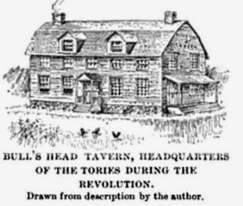
Almost all of Staten Island's Dutch, Flemish and Huguenot architecture has been destroyed by development and insensitivity to the Island's extraordinary 17th Century Dutch and English history. I will eventually identify the exact or approximate locations of each structure and their relation to the Revolutionary War, Loyalist and Rebel.
 |
| A View of...The Narrows...1777 by J.F.W. Des Barres |
Map of the Hudson ... from Sandy Hook to New York Harbor
(detail) from Map of the Hudson between Sandy Hook & Sandy Hill : with the post road between New York and Albany / Bridges delt. ; Rollinson sct. (1820)

A Map of the Province of New York, with Part of Pensilvania, and New England, from an Actual Survey by Captain [John] Montrésor, Engineer, 1775. P. Andrews, sculp. (London: A Dury, 1775). Detail shown.


(Old) Blazing Star Ferry (now the neighborhood of Rossville) was named after a Tavern by the same name near the ferry. See the detail (below) of a much later map showing a ferry dock labeled "Seguine."

The New Blazing Star Ferry (see below, approx. at water's edge near the label, RTE Hacock) in Long Neck (the end of the Richmond Turnpike, now Victory Boulevard) was another Ferry maintained by the Mesereau family during the Revolutionary War.
The Mersereau Brothers
New York-Philadelphia
via Bergen Point and Woodbridge
seats on springs
1764
New York-Philadelphia
via Bergen Point and Woodbridge
seats on springs
1764

A view of Paulus Hook (Bergen Neck).
Vue de Paulus Hook prise de l'apartement de Mde. la Mquise. de Brehan à New York.1789
.jpg)

Butler's Tavern, Morning Star Road (now Richmond Avenue) at Graniteville, reputed to be where Loyalist Lt.-Col. Dongan was mortally wounded during a skirmish with the Rebels in 1777.
The Fountain Hotel (below left), ordered to be burned by General Sullivan during his invasion of Staten Island, was save by the British. The Governor Dongan House was down the road, a piece (below right).


 The Barne-Tysen Homestead was located at Karle's Neck (New Springville) on Richmond Creek. It is demolished.
The Barton Homestead, at New Dorp. Demolished.


Britton Mill. Demolished.


The Britton Farm. Demolished.
 The Cucklestown Inn (at Richmond Towne), where Major John Andre signed his last will and testament before being hanged for being a spy.
 |
 |
 |
This Farmhouse (pictures at left) was used as a hideout for Loyalist Spies who foraged for the British Army. It was located near the first Methodist Church built on Staten Island. Demolished.
The Winant Homestead in Woodrow.
Another view of the Winant Homestead in Woodrow. Demolished.
Postcard describing Law Office of Hon. Cortlandt Skinner, King's Attorney for the province of New Jersey. Demolished.